A massive cold wave is extending over most of the European continent with snow and potential morning frosts over the weekend.
![]() The Arctic outbreak is now spreading south into southwestern Europe and Iberia thanks to a large surface depression over central Europe and the Mediterranean.The further strengthening of the trough will also intensify the cold weather, so temperatures will be much lower on Saturday and Sunday. Close to around 15°C below normal in the lowest levels from today through the weekend.Days will be much colder than the average for early April, particularly across western and central Europe.Where skies will be clear, very cold mornings with potential frosts could follow, particularly over the weekend and on Monday morning.
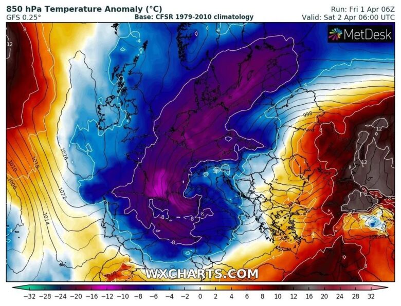
The Arctic outbreak is now spreading south into southwestern Europe and Iberia thanks to a large surface depression over central Europe and the Mediterranean.The further strengthening of the trough will also intensify the cold weather, so temperatures will be much lower on Saturday and Sunday. Close to around 15°C below normal in the lowest levels from today through the weekend.Days will be much colder than the average for early April, particularly across western and central Europe.Where skies will be clear, very cold mornings with potential frosts could follow, particularly over the weekend and on Monday morning.
![]() This will also trigger snowfall in parts of western and central Europe where the interaction of moist air mass from the south with the much colder air from the north will meet.Although the snowfall should not be particularly heavy, accumulating snow is forecast in the wake of the surface low across eastern France, Benelux and Germany.Also farther east across part of Czechia into southern Poland along the southward moving cold front through Friday night.Snow accumulations are forecast to be quite high over the Alps, but a lot of snow could also develop across the higher Apennines once the stronger cold arrives on Saturday.Potentially a lot of snow also in parts of central Germany at higher elevations.
This will also trigger snowfall in parts of western and central Europe where the interaction of moist air mass from the south with the much colder air from the north will meet.Although the snowfall should not be particularly heavy, accumulating snow is forecast in the wake of the surface low across eastern France, Benelux and Germany.Also farther east across part of Czechia into southern Poland along the southward moving cold front through Friday night.Snow accumulations are forecast to be quite high over the Alps, but a lot of snow could also develop across the higher Apennines once the stronger cold arrives on Saturday.Potentially a lot of snow also in parts of central Germany at higher elevations.
![]() Graphics provided by Wxcharts.com#nextclima#arcticoutbreak#coldspell#coldoutbreak#coldsnap#extremeweather#aprilfools#aprilfoolsday#winterisback#wintryweather#benelux#france#germany#czechia#poland#alps#apennines
Graphics provided by Wxcharts.com#nextclima#arcticoutbreak#coldspell#coldoutbreak#coldsnap#extremeweather#aprilfools#aprilfoolsday#winterisback#wintryweather#benelux#france#germany#czechia#poland#alps#apennines


