A powerful storm system will track across the central U.S. next week with forecast impacts including snow and the potential for blizzard conditions in the Northern Plains as well as widespread heavy rain and severe weather from the Southern Plains to the Mississippi Valley.
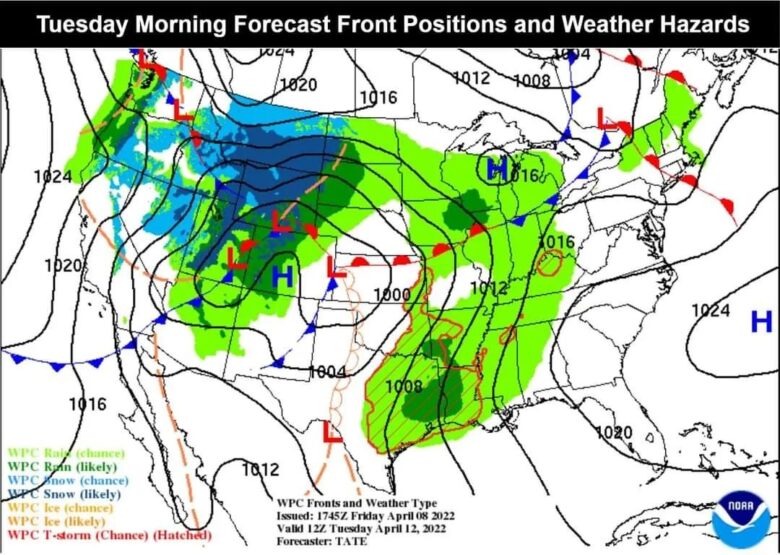
![]() It is becoming likely that a large winter storm will bring heavy snow and strong winds to portions of the Northern Rockies, Northern Plains and Upper Midwest next week. Hazardous travel and power outages are possible.Snow could be heavier at times in the higher elevations, especially in the Cascades of Oregon.Snow will spread through much of the West on Monday before spreading into the northern Plains by Monday night into early Tuesday.On Tuesday, colder air will wrap around the strengthening low pressure system, which will bring heavier snow to the Colorado Rockies and parts of Montana and North Dakota.
It is becoming likely that a large winter storm will bring heavy snow and strong winds to portions of the Northern Rockies, Northern Plains and Upper Midwest next week. Hazardous travel and power outages are possible.Snow could be heavier at times in the higher elevations, especially in the Cascades of Oregon.Snow will spread through much of the West on Monday before spreading into the northern Plains by Monday night into early Tuesday.On Tuesday, colder air will wrap around the strengthening low pressure system, which will bring heavier snow to the Colorado Rockies and parts of Montana and North Dakota.
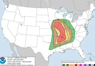
![]() Several days of strong to severe thunderstorms are expected in the southern Plains.The threat of severe weather will expand to much of the Mississippi Valley.Severe storms could become more numerous and widespread Tuesday and Wednesday as the large low pressure system nears.Thunderstorms will be possible from the southern Plains to Iowa on Tuesday while severe storms are expected from central or eastern Iowa northward to eastern Kansas and western Missouri.Given the recent rounds of severe weather across the South, there is at least some threat of flash flooding where heavy rain occurs.Some spots may pick up 2-4″ of rain in the upcoming work week.
Several days of strong to severe thunderstorms are expected in the southern Plains.The threat of severe weather will expand to much of the Mississippi Valley.Severe storms could become more numerous and widespread Tuesday and Wednesday as the large low pressure system nears.Thunderstorms will be possible from the southern Plains to Iowa on Tuesday while severe storms are expected from central or eastern Iowa northward to eastern Kansas and western Missouri.Given the recent rounds of severe weather across the South, there is at least some threat of flash flooding where heavy rain occurs.Some spots may pick up 2-4″ of rain in the upcoming work week.
![]() Credits: NOAA #nextclima#extremeweather#severeweather#winterstorm#snowstorm#storm#rockies#colorado#montana#dakota#plains#oregon#midwest#mississippivalley#kansas#missouri#iowa
Credits: NOAA #nextclima#extremeweather#severeweather#winterstorm#snowstorm#storm#rockies#colorado#montana#dakota#plains#oregon#midwest#mississippivalley#kansas#missouri#iowa