On Friday the arrival of a strong cold front farther south into the Southeast U.S. and East Coast will bring much lower temperatures, potentially more than 20 degrees F below normal for late November in these areas.
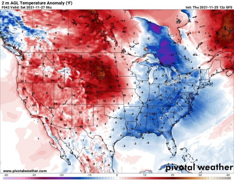
![]() The strongest cold for the East will develop on Saturday.The East Coast, Southeast U.S., as well as part of the Gulf Coast should see temperatures about 10-15°F below the average for this time.A chilly day in much of Florida as well, with winds worsening those conditions.On the contrary, will be the warmth across the Northern Plains (Dakotas) once again.Nearly 20°F above normal near the surface.Thanks to the dry layers coming down from the High Plains and Rockies.
The strongest cold for the East will develop on Saturday.The East Coast, Southeast U.S., as well as part of the Gulf Coast should see temperatures about 10-15°F below the average for this time.A chilly day in much of Florida as well, with winds worsening those conditions.On the contrary, will be the warmth across the Northern Plains (Dakotas) once again.Nearly 20°F above normal near the surface.Thanks to the dry layers coming down from the High Plains and Rockies.
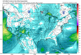
![]() On Friday, the surface low deepens considerably over the Great Lakes, continues with more rapid deepening as we head into the next weekend.A major winter storm is forecast to develop across the Northeast. How intense the snowfall will develop strongly depends on the storm’s track, but it seems the low will be pretty deep.And so will be the winds, and temperatures becoming pretty cold.Through Friday night, the winter storm will gradually intensify while moving further northeast towards southeast Canada on Saturday.The most intense snowfall will likely spread across northern Vermont, New Hampshire into Maine, more into Canadian Ontario and New Brunswick.
On Friday, the surface low deepens considerably over the Great Lakes, continues with more rapid deepening as we head into the next weekend.A major winter storm is forecast to develop across the Northeast. How intense the snowfall will develop strongly depends on the storm’s track, but it seems the low will be pretty deep.And so will be the winds, and temperatures becoming pretty cold.Through Friday night, the winter storm will gradually intensify while moving further northeast towards southeast Canada on Saturday.The most intense snowfall will likely spread across northern Vermont, New Hampshire into Maine, more into Canadian Ontario and New Brunswick.
![]() Graphics provided by Pivotal Weather #nextclima#snowfall#snowstorm#winter#winterstorm#blizzard#snow#coldoutbreak#cold#eastcoast#florida#gulfcoast#greatlakes#vermont#newhampshire#maine#ontario#newbrunswick#severeweather#extremeweather
Graphics provided by Pivotal Weather #nextclima#snowfall#snowstorm#winter#winterstorm#blizzard#snow#coldoutbreak#cold#eastcoast#florida#gulfcoast#greatlakes#vermont#newhampshire#maine#ontario#newbrunswick#severeweather#extremeweather