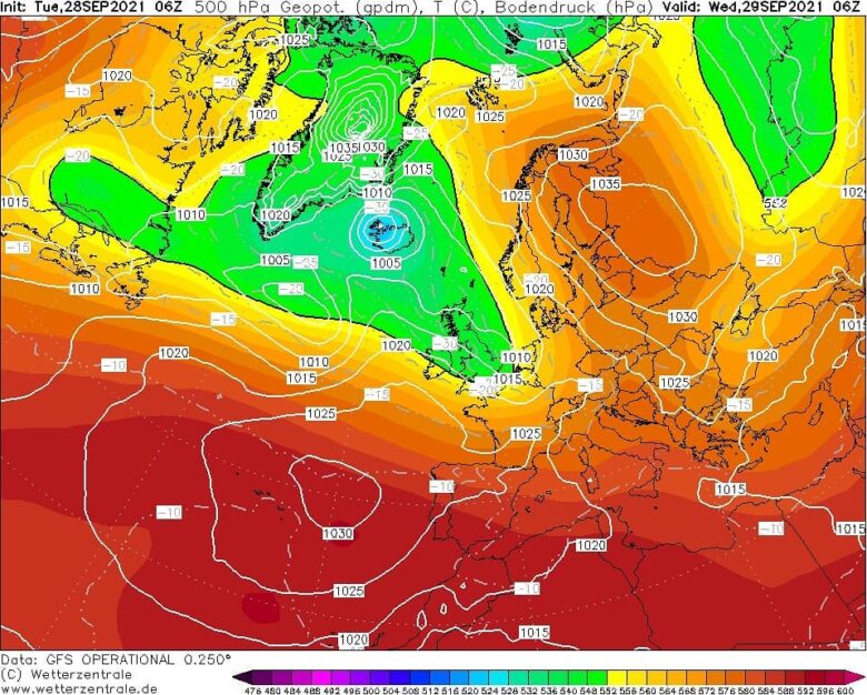
A significantly colder air mass advection is expected towards western Europe in the next few days.![]() Today a cold air mass will strengthen and deepen, in response to an upper wave moving into western Europe and deepening the central pressure over northwestern Europe.Temperatures across the lowest parts of the atmosphere will be about 6-8°C colder than normal with daytime maximum staying in the low 10s across northern UK and Ireland on Tuesday. Wednesday morning will be quite cold actually, with temperatures ending only a few degrees above zero in some areas.The lowest over Scotland and eastern Ireland, roughly 2-3°C only (a few degrees warmer morning over southern England). <
Today a cold air mass will strengthen and deepen, in response to an upper wave moving into western Europe and deepening the central pressure over northwestern Europe.Temperatures across the lowest parts of the atmosphere will be about 6-8°C colder than normal with daytime maximum staying in the low 10s across northern UK and Ireland on Tuesday. Wednesday morning will be quite cold actually, with temperatures ending only a few degrees above zero in some areas.The lowest over Scotland and eastern Ireland, roughly 2-3°C only (a few degrees warmer morning over southern England). <![]() This generally cooler period is forecast to continue through much of this week and also into the next weekend, as a deep North Atlantic depression will keep maintaining the cold advection towards western Europe.Unsettled rainy and windy conditions should be expected.Both Thursday and Friday will be a few degrees colder than normal over France, Benelux, and Germany, with Friday bringing some colder also across central Europe.At the same time, a large cold air mass associated with strong High over Russia will continue with very cold days across southeastern parts of Europe, especially over Turkey. The daytime temperature there will be about 6-10°C below normal for this period. Mornings will be frosty across the eastern half of the country.
This generally cooler period is forecast to continue through much of this week and also into the next weekend, as a deep North Atlantic depression will keep maintaining the cold advection towards western Europe.Unsettled rainy and windy conditions should be expected.Both Thursday and Friday will be a few degrees colder than normal over France, Benelux, and Germany, with Friday bringing some colder also across central Europe.At the same time, a large cold air mass associated with strong High over Russia will continue with very cold days across southeastern parts of Europe, especially over Turkey. The daytime temperature there will be about 6-10°C below normal for this period. Mornings will be frosty across the eastern half of the country.![]() Graphics provided by Wetterzentrale
Graphics provided by Wetterzentrale
#nextclima#temperaturedrop#coldoutbreak#coldwave#fall#2021fall#westerneurope#uk#ireland#scotland#england#france#benelux#germany#russia#turkey#extremeweather
A colder air mass advection is expected towards western Europe