Ex-Hurricane Danielle is expected to influence the weather across western Europe early next week, but with a lot of uncertainty over the details due to changes of the possible track.
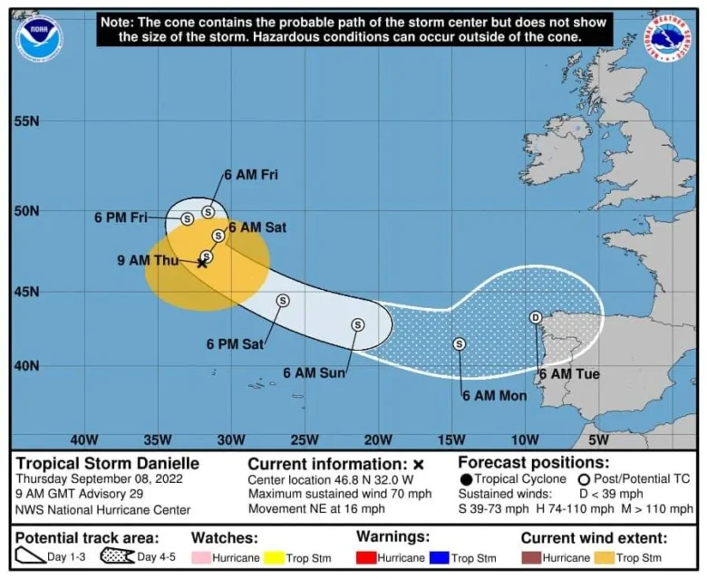
🌀 Above is the latest guidance from the National Hurricane Center for 09:00GMT Today, with Danielle now weakened to a Tropical Storm with Maximum winds of 70mph and expected to become post-tropical later today.
Danielle is forecast to continue weakening and to approach northwest Iberia early next week, as a likely typical Autumn storm/depression.
At the moment, for Portugal, Spain, France and UK there are still uncertainties over how much rain they will see and the timing.
➡️ The ECMWF model takes its time to move the frontal rain into SW Britain on Sunday but then the rainband slows over Northern Ireland and western Britain, feeding heavy rain in the same place.
This will bring the risk of flooding for the start of the new week.
Portugal and NW Spain face a similar forecast, with torrential rain.
The GFS model shows a similar frontal structure move up from the southwest on Sunday, with less engagement of UK due to a second low centre south of Iceland.
Follow our next updates.
📸 Graphics provided by NOAA and Wetterzentrale


