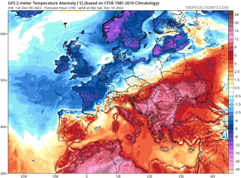
This weekend the European continent will see a strong temperature contrast with an Arctic outbreak spreading across northern, central and western Europe and very warm air developing into the Balkans, Ukraine and the Black Sea.
❄️ The Arctic blast is beginning its journey from Scandinavia towards the south, overspreading western, central Europe and later on also eastern Europe and the northern Balkans early next week.
Temperatures are forecast to be more than 10 °C below average for mid-December.
Most of Europe will see colder weather, except the far southern and southeastern Europe before the cold mixed there as well.
The warmth ahead of the winter storm will be strongly anomalous over the Balkans and the Black Sea region, more than 10°C warmer.
🌨 The colder air across central Europe is delivering some significant amounts of snow into the Alps.
Today in southern Alps snow has fallen to even well below 1,000 metres, but tomorrow the snowline will temporary rise by several hundred metres due to warmer air from the Mediterranean.
Other significant amounts of snow are forecast over the next few days across the northern Balkan countries, as well as farther northeast into Poland and Baltic countries.
Global weather models also hint at some fresh snow potentially coming up late next week for the UK, Germany, France and Benelux.
📸 Graphics provided by Tropicaltidbits


