A deep North Atlantic depression will keep maintaining the first autumnal cold advection towards western Europe.![]() Unsettled rainy and windy conditions should be expected in the next few days.Peak wind gusts are likely to be extremely intense in the Denmark Strait, the narrow part of the Atlantic between Iceland and Greenland.Thanks to the very strong pressure gradient across the Strait, peak wind gusts could exceed 160-180 km/h there. As the large depression remains in place, a relatively strong wind field also brings windy and unsettled conditions around its core, across the North Atlantic towards Ireland and western Scotland, as well as across the North Sea.
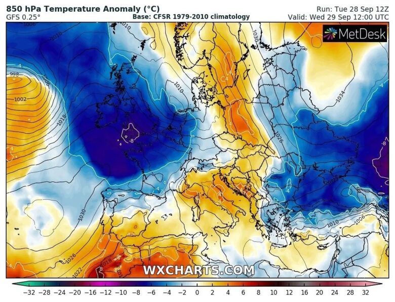
Unsettled rainy and windy conditions should be expected in the next few days.Peak wind gusts are likely to be extremely intense in the Denmark Strait, the narrow part of the Atlantic between Iceland and Greenland.Thanks to the very strong pressure gradient across the Strait, peak wind gusts could exceed 160-180 km/h there. As the large depression remains in place, a relatively strong wind field also brings windy and unsettled conditions around its core, across the North Atlantic towards Ireland and western Scotland, as well as across the North Sea.![]() The large North Atlantic depression is forecast to persist over the same part of the region through this whole week, so the cold advection also gradually spreads further east after Wednesday. Cold will spread towards central Europe in the next few days and the weekend could bring another deep low into western Europe from the Atlantic. The new strong frontal system could potentially bring severe winds and dangerous weather. Follow our next updates.
The large North Atlantic depression is forecast to persist over the same part of the region through this whole week, so the cold advection also gradually spreads further east after Wednesday. Cold will spread towards central Europe in the next few days and the weekend could bring another deep low into western Europe from the Atlantic. The new strong frontal system could potentially bring severe winds and dangerous weather. Follow our next updates.![]() Graphics provided by wxcharts.com
Graphics provided by wxcharts.com
#nextclima#fall#fall2021#temperaturedrop#cold#westerneurope#france#benelux#germany#uk#ireland#england#scotland#centraleurope#windstorm#denmarkstrait#severeweather#extremeweather
First autumnal cold advection