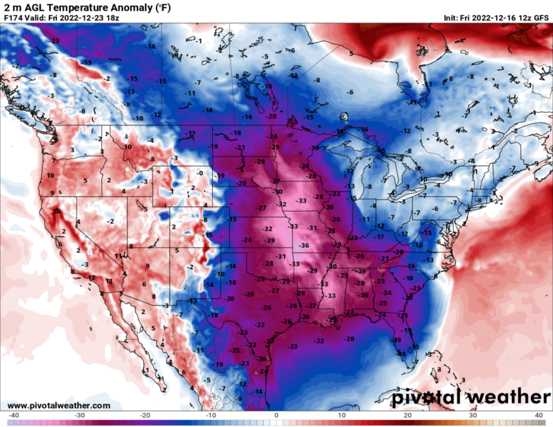
Some of the coldest December weather in decades may plunge into the central and eastern U.S. with snow possible before Christmas Eve.
1️⃣ The initial blast of cold will drive southward into the northern Rockies and northern Plains on Monday and Tuesday, reaching the Great Lakes Tuesday into Wednesday.
Some of the coldest areas near the border with Canada could see temperatures 30 to 40 degrees F° below normal, meaning highs around minus-10 and lows from minus-20 to minus-30.
Subzero temperatures could reach as far south as the central Plains.
2️⃣ A second, reinforcing blast of cold may dive into the northern Plains and Upper Midwest Wednesday and Thursday, pushing frigid air even farther south and east. Minneapolis should expect lows well below zero while Chicago may see highs only in the teens for much of the second half of next week.
By Christmas Eve and Christmas Day, much of the eastern half of the country may see temperatures 10 to 30 degrees F° below normal.
🌨 The potential for snowfall will stretch from the Plains to the East Coast during the second half of next week.
A snowfall is forecast to break out over the central and northern Plains before sweeping across the Midwest and Tennessee and Ohio valleys.
The timing would probably be around Wednesday into Thursday.
The disturbance that could bring snow to the central states could evolve into a major East Coast storm.
The timing of this storm would probably be between Thursday and Christmas Eve.
📸 Graphics provided by Pivotal Weather