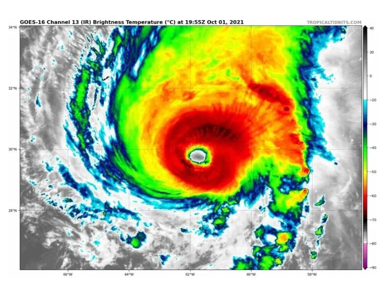
Major hurricane Sam is a solid, high-end Category 4 storm and is not expected to intensify any further but will remain over very warm oceanic waters for a few more days, while wind shear is low.![]() This should allow it to remain a major hurricane for another day or two before a gradual weakening begins. The majority of the model forecasts keep the hurricane Sam at a powerful Category 3 or greater strength over the next few days.Even at times when the transition to extratropical storm occurs in the Northwest Atlantic sometime from Monday to Tuesday.
This should allow it to remain a major hurricane for another day or two before a gradual weakening begins. The majority of the model forecasts keep the hurricane Sam at a powerful Category 3 or greater strength over the next few days.Even at times when the transition to extratropical storm occurs in the Northwest Atlantic sometime from Monday to Tuesday.![]() Large swells generated by Sam will impact the northern Leeward Islands, the Greater Antilles, the Bahamas, and Bermuda during the next couple of days and also reach the United States East Coast and Atlantic Canada on Saturday. These swells could cause life-threatening surf and rip current conditions.<
Large swells generated by Sam will impact the northern Leeward Islands, the Greater Antilles, the Bahamas, and Bermuda during the next couple of days and also reach the United States East Coast and Atlantic Canada on Saturday. These swells could cause life-threatening surf and rip current conditions.<![]() After passing Bermuda this weekend, hurricane Sam is forecast to take a northeast turn into the North Atlantic. Sam is then expected to slowly weaken as it moves over progressively cooler waters and into an environment of stronger shear. The hurricane will likely begin the extratropical transition in a couple of days when it crosses the 26 degrees C isotherm, and this transition is expected to be completed shortly after 72 hours.
After passing Bermuda this weekend, hurricane Sam is forecast to take a northeast turn into the North Atlantic. Sam is then expected to slowly weaken as it moves over progressively cooler waters and into an environment of stronger shear. The hurricane will likely begin the extratropical transition in a couple of days when it crosses the 26 degrees C isotherm, and this transition is expected to be completed shortly after 72 hours. ![]() Graphics provided by Tropicaltidbits and NOAA
Graphics provided by Tropicaltidbits and NOAA
#nextclima#sam#hurricanesam#hurricane#northatlantic#bermuda#leewardislands#bahamas#lesserantilles#atlanticocean#hurricaneseason#stormsurge#majorwaves#extremeweather#severeweather
Major hurricane Sam is a high-end Category 4 storm