This weekend a blocking High is strengthening across the western portions of the American continent, with a new intrusion of Arctic air mass to its east by early next week.
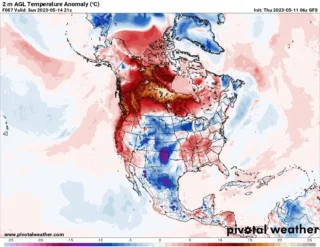
![]() The weather pattern across North America has remained very active also this week, with a deep trough over the western part of the continent against the strong blocking High placed across the western portions of the U.S.A significantly deep upper trough brought frigid cold airmass into western Canada and Northwest U.S. through early January.This weekend the significantly colder than normal Arctic air mass will push east-southeastward from central Canada prairies, putting regions from the Midwest across the Great Lakes to the Northeast into deep freeze.
The weather pattern across North America has remained very active also this week, with a deep trough over the western part of the continent against the strong blocking High placed across the western portions of the U.S.A significantly deep upper trough brought frigid cold airmass into western Canada and Northwest U.S. through early January.This weekend the significantly colder than normal Arctic air mass will push east-southeastward from central Canada prairies, putting regions from the Midwest across the Great Lakes to the Northeast into deep freeze.
![]() The cold pool will be the coldest of the winter season 2021/22 so far for Ontario, Canada, and also for the areas around the Lakes, Ohio Valley, Appalachians, and the Northeast U.S.Daytime temperatures are forecast to dip into the teens during Sunday afternoon around Chicago, and push even lower through Sunday night and remain in the lowe 10s on Monday.It hasn’t been as cold yet this season in this part of the country.
The cold pool will be the coldest of the winter season 2021/22 so far for Ontario, Canada, and also for the areas around the Lakes, Ohio Valley, Appalachians, and the Northeast U.S.Daytime temperatures are forecast to dip into the teens during Sunday afternoon around Chicago, and push even lower through Sunday night and remain in the lowe 10s on Monday.It hasn’t been as cold yet this season in this part of the country.
![]() After Monday, the cold air advances further into the Northeast, with temperatures reaching the lower 20s or even upper 10s during the day in New York City on Tuesday.With the nighttime temperatures likely to reach low 10s or even single digits °F for the first time this winter season in Washington, D.C., on Monday and Tuesday next week.Tuesday will be even colder farther east, with -20 to -30°F in the morning.That is nearly 25 to 30°F below normal for southern Ontario.
After Monday, the cold air advances further into the Northeast, with temperatures reaching the lower 20s or even upper 10s during the day in New York City on Tuesday.With the nighttime temperatures likely to reach low 10s or even single digits °F for the first time this winter season in Washington, D.C., on Monday and Tuesday next week.Tuesday will be even colder farther east, with -20 to -30°F in the morning.That is nearly 25 to 30°F below normal for southern Ontario.
![]() Graphics provided by Pivotal
Graphics provided by Pivotal
Weather#nextclima#coldoutbreak#arcticblast#winter#january2022#forecast#weather#extremeweather#extremecold#chicago#newyorkcity#appalachians#washington#ontario#ohiovalley#midwest#greatlakes#canada#northeastus