After a long period of high pressure in October, November starts off with some amazing weather charts, since much of Europe will enter a much cooler and more changeable phase starting tomorrow.
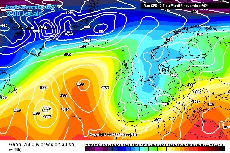
![]() In the next few days the first Arctic blast of the season will spread across northern and then central Europe.Maximum temperatures won’t exceed 8-9°C in Germany, Benelux, Czech Republic, Austria and Switzerland.First snowfalls are expected in the northern Alps above 800 meters of altitude, especially in Switzerland, Austria and the French Massif Central.Snow also in in the plain in Scotland and in Germany starting from 900 meters of altitude. In the southern Alps, a large scale of half a meter of snow is possible according to several weather models with a snowline around 1800 to 2000 meters.
In the next few days the first Arctic blast of the season will spread across northern and then central Europe.Maximum temperatures won’t exceed 8-9°C in Germany, Benelux, Czech Republic, Austria and Switzerland.First snowfalls are expected in the northern Alps above 800 meters of altitude, especially in Switzerland, Austria and the French Massif Central.Snow also in in the plain in Scotland and in Germany starting from 900 meters of altitude. In the southern Alps, a large scale of half a meter of snow is possible according to several weather models with a snowline around 1800 to 2000 meters.
![]() Starting from Nov.10 a second Arctic outbreak is expected across central and then southern Europe.This time also Italy and the Balkans may experience cooler than average temperatures.It will be the first cold outbreak of the season for many countries, with widespread night frosts and first snowfalls at low altitudes.This period could be long-lasting and the whole month of November will be more dynamic with frequent cold fronts spreading across much of Europe.
Starting from Nov.10 a second Arctic outbreak is expected across central and then southern Europe.This time also Italy and the Balkans may experience cooler than average temperatures.It will be the first cold outbreak of the season for many countries, with widespread night frosts and first snowfalls at low altitudes.This period could be long-lasting and the whole month of November will be more dynamic with frequent cold fronts spreading across much of Europe.
![]() Graphics provided by Meteociel #nextclima#onda#ondamodel#forecast#temperatureoutlook#temperaturetrend#arcticblast#coldoutbreak#firstsnow#snowfall#alps#centraleurope#germany#czechrepublic#austria#switzerland#benelux#scotland#italy#balkans
Graphics provided by Meteociel #nextclima#onda#ondamodel#forecast#temperatureoutlook#temperaturetrend#arcticblast#coldoutbreak#firstsnow#snowfall#alps#centraleurope#germany#czechrepublic#austria#switzerland#benelux#scotland#italy#balkans


