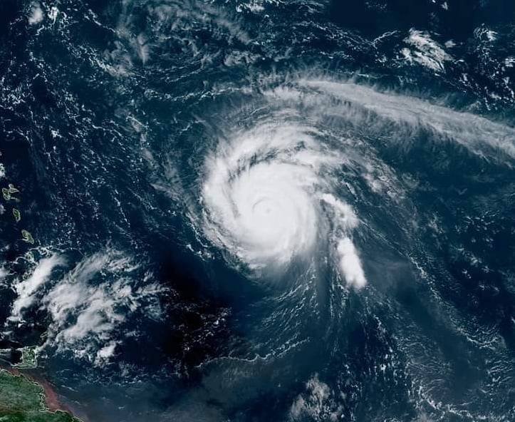
Sam will likely remain a strong hurricane as it moves northwest over the next five days, well north of the Leeward Islands.![]() The minimum central pressure estimated from NOAA Hurricane Hunter aircraft observations is 966 mb (28.53 inches).Maximum sustained winds are near 125 mph (205 km/h) with higher gusts, a category 3 hurricane on the Saffir-Simpson Hurricane Wind Scale. Fluctuations in intensity are possible during the next several days, but Sam is forecast to remain a major hurricane through at least Thursday night. Hurricane-force winds extend outward up to 30 miles (45 km) from the center and tropical-storm-force winds extend outward up to 105 miles (165 km).
The minimum central pressure estimated from NOAA Hurricane Hunter aircraft observations is 966 mb (28.53 inches).Maximum sustained winds are near 125 mph (205 km/h) with higher gusts, a category 3 hurricane on the Saffir-Simpson Hurricane Wind Scale. Fluctuations in intensity are possible during the next several days, but Sam is forecast to remain a major hurricane through at least Thursday night. Hurricane-force winds extend outward up to 30 miles (45 km) from the center and tropical-storm-force winds extend outward up to 105 miles (165 km).![]() Swells generated by Sam will reach the Lesser Antilles today and impact these islands for the next several days. Swells are expected to reach Bermuda and the Bahamas mid-to-late week, and then spread to the United States east coast late this week. These swells could cause life-threatening surf and rip current conditions.<
Swells generated by Sam will reach the Lesser Antilles today and impact these islands for the next several days. Swells are expected to reach Bermuda and the Bahamas mid-to-late week, and then spread to the United States east coast late this week. These swells could cause life-threatening surf and rip current conditions.<![]() Computer model forecasts are in agreement that Sam will curl well away from the U.S. East Coast as it tracks through the Atlantic into next weekend. Sam could at least generate high surf and rip currents along the East Coast by late this week or next weekend, as Hurricane Larry did earlier this month despite passing east of Bermuda. Bermuda could eventually be threatened by Sam late this week or next weekend. However, it’s too early to know if that will happen and interests there should monitor the progress of Sam closely.
Computer model forecasts are in agreement that Sam will curl well away from the U.S. East Coast as it tracks through the Atlantic into next weekend. Sam could at least generate high surf and rip currents along the East Coast by late this week or next weekend, as Hurricane Larry did earlier this month despite passing east of Bermuda. Bermuda could eventually be threatened by Sam late this week or next weekend. However, it’s too early to know if that will happen and interests there should monitor the progress of Sam closely.![]() Credits: NOAA
Credits: NOAA
#nextclima#hurricanesam#sam#hurricane#atlanticocean#leewardislands#bermuda#eastcoast#bahamas#lesserantilles#stormsurge#majorwaves#severeweather#extremeweather
Sam will likely remain a strong hurricane