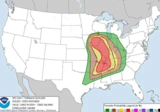
There is an increasing potential for a multi-day severe thunderstorm outbreak across the central U.S.
⛈️ The first round of severe thunderstorms will likely develop across Kansas, Nebraska and South Dakota on Friday where storms could bring large hail, severe winds, and a few tornadoes.
The day after, on Saturday, a more robust severe thunderstorm conditions are forecast to develop as the surface low will be deep while traveling across the northern Plains.
This will result in a major return of significantly moist and warmer air mass far north of the Gulf of Mexico under the powerful jet stream aloft.
Therefore, severe thunderstorms will become more widespread from Saturday afternoon into Sunday morning along the front from Minnesota to Oklahoma.
🌪 Thunderstorms with higher potential for tornadoes, even strong ones, severe damaging winds and large to very hail with local flooding will be possible from the late afternoon into the Saturday night hours.
Areas across Oklahoma to Iowa and Minnesota will be in the highest threat of the most robust severe storms, gradually spreading east through the night hours as the front advances further.
Supercell thunderstorms will follow with large hail, severe winds, a few tornadoes and heavy rainfall.
On Sunday, when the parent low-pressure system moves into Upper Midwest, the cold front will develop more severe thunderstorms from the western Ohio Valley across central Missisippi Valley towards Texas, again with robust severe weather potential.
📸 Graphics provided by Pivotal Weather