Storm Franklin will continue moving southeast through Sunday night with violent winds across Ireland, Northern Ireland and the UK.
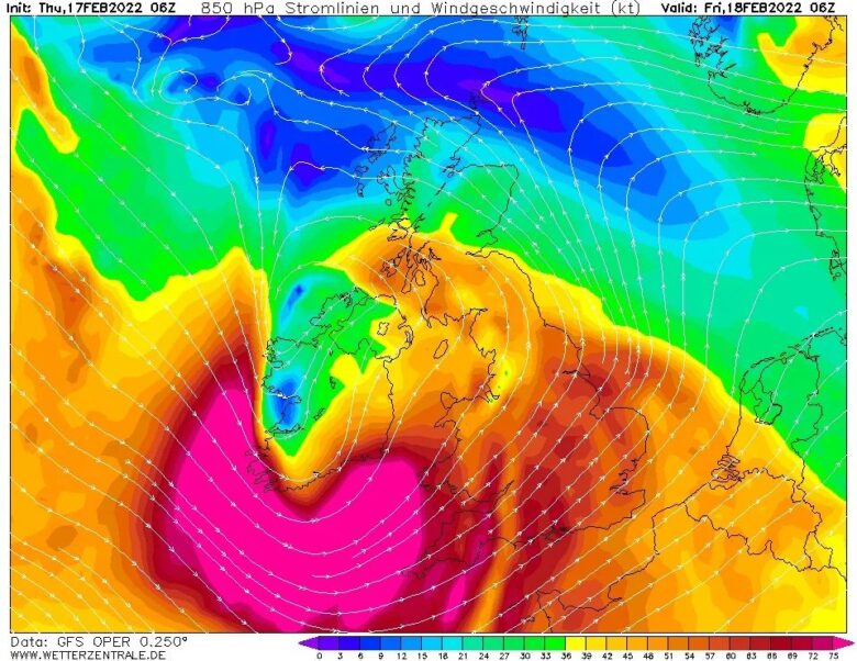
![]() Franklin is traveling from the south of Iceland across Scotland Sunday night, reaching Denmark on Monday morning with gradually rising central pressure but remaining very intense.The weather models are hinting at some pretty rough weather across a large portion of western Europe again, with heavy rain and severe wind squalls to the south of the center low and behind the main cold front.Graupel showers are also possible to be mixing with cooler maritime air mass from the Atlantic.
Franklin is traveling from the south of Iceland across Scotland Sunday night, reaching Denmark on Monday morning with gradually rising central pressure but remaining very intense.The weather models are hinting at some pretty rough weather across a large portion of western Europe again, with heavy rain and severe wind squalls to the south of the center low and behind the main cold front.Graupel showers are also possible to be mixing with cooler maritime air mass from the Atlantic.
![]() The highest wind gusts could reach well above 80 mph, possibly even close to 100-125 mph (160-200 km/h) locally again, just off the coast to the west-northwest. So large and intense wind fields will also generate huge sea waves, which will likely exceed 16 meters near the center of the wind maximum and gradually spread southeast while the system will be advancing towards Scotland and the North Sea Sunday night.Waves will be of major heights with large swell across the whole western coast of Scotland, Northern Ireland, and western Ireland.Those could be up to 12-14 meters as well, causing damage to the coastal areas and erosion.
The highest wind gusts could reach well above 80 mph, possibly even close to 100-125 mph (160-200 km/h) locally again, just off the coast to the west-northwest. So large and intense wind fields will also generate huge sea waves, which will likely exceed 16 meters near the center of the wind maximum and gradually spread southeast while the system will be advancing towards Scotland and the North Sea Sunday night.Waves will be of major heights with large swell across the whole western coast of Scotland, Northern Ireland, and western Ireland.Those could be up to 12-14 meters as well, causing damage to the coastal areas and erosion.
![]() Graphics provided by Wxcharts.com#nextclima#stormfranklin#franklin#windstorm#atlanticstorm#northatlantic#uk#ireland#scotland#northsea#denmark#severeweather#extremeweather
Graphics provided by Wxcharts.com#nextclima#stormfranklin#franklin#windstorm#atlanticstorm#northatlantic#uk#ireland#scotland#northsea#denmark#severeweather#extremeweather