The last update of our Onda model confirms the temperature trend for Europe identified last week for the next two months.
🌡 By Friday, a frontal boundary will have pushed right down through France, Spain, the western Mediterranean, the Alps and Germany allowing cooler air over much of western Europe.
By Saturday, this will have swept through Italy and be pestering the Adriatic coast and western Greece.
As a consequence, there will be a temperature drop compared to the values recorded over the last few days, but this will be a return to average or slightly below average temperatures for the period.
An anticyclonic recovery over most of Europe is likely next week, especially by the end of next week, with a return to more stable conditions and above-average temperatures particularly over Portugal, Spain, Italy and eastern Europe.
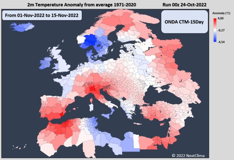
➡️ But a big change is forecast starting from mid-November, when some negative temperature anomalies are expected across northwestern and then central Europe.
This time the UK, France, Benelux, Germany, Italy and other countries in central Europe may experience cooler than average temperatures.
The second part of November will be more dynamic with frequent cold fronts spreading across much of Europe, while December seems to be more stable, due to the strengthening of the Polar Vortex.
Warmer than average temperatures are forecast for most of December over large part of Europe, whereas it is very likely that the UK will have a cold and snowy winter.
📸 Credits by NextClima


