The first snow of the season is on the way for parts of the Midwest and Great Lakes from a pair of weather systems, one a windy storm that could bring blizzard conditions for some.
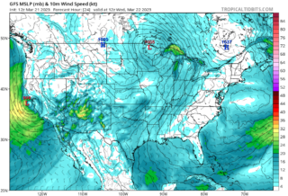
![]() A sharp, southward plunge of the jet stream is building into the eastern half of the U.S.That has spawned a strong Midwest storm that will pull much colder air out of Canada into the central and eastern U.S.After that storm moves away, another system this weekend will then sweep through this jet stream into the colder air this weekend.By Sunday and Sunday night, this system may wring out some wet snow over parts of the Great Lakes and the interior Northeast.While amounts less than an inch are generally expected, snowfall from this clipper system could be the season’s first measurable snow in Chicago, Columbus, Detroit, Milwaukee and Pittsburgh.Modest accumulations are expected in Great Lakes snowbelts, where bands of lake-effect snow may persist from Friday through Monday.
A sharp, southward plunge of the jet stream is building into the eastern half of the U.S.That has spawned a strong Midwest storm that will pull much colder air out of Canada into the central and eastern U.S.After that storm moves away, another system this weekend will then sweep through this jet stream into the colder air this weekend.By Sunday and Sunday night, this system may wring out some wet snow over parts of the Great Lakes and the interior Northeast.While amounts less than an inch are generally expected, snowfall from this clipper system could be the season’s first measurable snow in Chicago, Columbus, Detroit, Milwaukee and Pittsburgh.Modest accumulations are expected in Great Lakes snowbelts, where bands of lake-effect snow may persist from Friday through Monday.
![]() North to northwest winds gusting at least to 40 mph are possible in the Dakotas, western Minnesota, Nebraska and western Iowa into Friday.High winds combined with falling snow may produce sudden reduced visibility and brief blizzard conditions in parts of the eastern Dakotas, even in areas where snowfall accumulations are expected to be light.Travel may become difficult in these areas.Blizzard warnings have been issued by the National Weather Service in northeast South Dakota and a few adjacent counties in west-central Minnesota.
North to northwest winds gusting at least to 40 mph are possible in the Dakotas, western Minnesota, Nebraska and western Iowa into Friday.High winds combined with falling snow may produce sudden reduced visibility and brief blizzard conditions in parts of the eastern Dakotas, even in areas where snowfall accumulations are expected to be light.Travel may become difficult in these areas.Blizzard warnings have been issued by the National Weather Service in northeast South Dakota and a few adjacent counties in west-central Minnesota.
![]() Graphics provided by Pivotal Weather #nextclima#blizzard#snowstorm#storm#snow#snowfall#dakotas#minnesota#nebraska#greatlakes#chicago#columbus#detroit#milwaukee#pittsburg#midwest#severeweather#extremeweather
Graphics provided by Pivotal Weather #nextclima#blizzard#snowstorm#storm#snow#snowfall#dakotas#minnesota#nebraska#greatlakes#chicago#columbus#detroit#milwaukee#pittsburg#midwest#severeweather#extremeweather