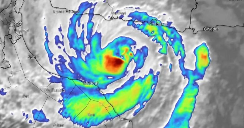
Tropical cyclone Shaheen (Gulab) is positioned in the northwest of the Arabian Sea with rainy convective clouds and strong winds of intensity of 120 km/h. ![]() Cyclone Shaheen is headed for historic landfall in Oman at hurricane-equivalent strength. No cyclone has made landfall in the country in the modern recordkeeping. Shaheen’s path is expected to continue towards the coasts of the Oman during the next 24 hours with landfall on Sunday afternoon. Tropical conditions will be mainly prevalent in the Fujairah and Al Ain. Residents are advised to stay away from beaches because waters are expected to rise. Affected regions will likely experience rains with different intensity leading to flash flooding in low lying areas, storm surge and high winds. <
Cyclone Shaheen is headed for historic landfall in Oman at hurricane-equivalent strength. No cyclone has made landfall in the country in the modern recordkeeping. Shaheen’s path is expected to continue towards the coasts of the Oman during the next 24 hours with landfall on Sunday afternoon. Tropical conditions will be mainly prevalent in the Fujairah and Al Ain. Residents are advised to stay away from beaches because waters are expected to rise. Affected regions will likely experience rains with different intensity leading to flash flooding in low lying areas, storm surge and high winds. <![]() The direct impact of the cyclone will start on Sunday morning and it will include strong winds (40-60) knots and heavy rain ranging between 200 and 500 mm causing severe flash floods in Governorates of North Al Batinah, South A Batinah, Muscat, Al Dhahira, Al Buraimi Al Dakhiliyah and the coastal areas of South Al Sharqiyah.The influences may extend to the Govemorates of Musandam, North Al Sharqiyah with isolated rain 30-80 mm and heavy to moderate winds (15-25 knots).
The direct impact of the cyclone will start on Sunday morning and it will include strong winds (40-60) knots and heavy rain ranging between 200 and 500 mm causing severe flash floods in Governorates of North Al Batinah, South A Batinah, Muscat, Al Dhahira, Al Buraimi Al Dakhiliyah and the coastal areas of South Al Sharqiyah.The influences may extend to the Govemorates of Musandam, North Al Sharqiyah with isolated rain 30-80 mm and heavy to moderate winds (15-25 knots). ![]() Sea condition is expected to be very rough over the coastal areas between South AI Sharqiyah and Musandam Governorates with maximum wave height ranging between 8 and 12 metres. In addition, storm surge might cause inundation of low-level coastal areas. The sea will be moderate to rough along the rest of Omani coasts with maximum wave height between 2 and 3 meters.
Sea condition is expected to be very rough over the coastal areas between South AI Sharqiyah and Musandam Governorates with maximum wave height ranging between 8 and 12 metres. In addition, storm surge might cause inundation of low-level coastal areas. The sea will be moderate to rough along the rest of Omani coasts with maximum wave height between 2 and 3 meters.
![]() Graphics provided by Windy and IMD
Graphics provided by Windy and IMD
#nextclima#tropicalcyclone#cycloneshaheen#cyclonegulab#shaheen#gulab#oman#landfall#arabiansea#stormsurge#majorwaves#flooding#flashflooding#severeweather#extremeweather
Tropical cyclone Shaheen (Gulab) in the Arabian Sea