Very cold weather with local winter storm events is developing across the eastern and central parts of Europe, including the Balkans.
![]() Strong high-pressure systems expand from the Azores into southwestern and western Europe, while a broad region of lower pressure spreads across eastern Europe into the Black Sea region.The high-pressure system covers a large part of northern, western, and southwestern Europe, while surface pressure is lower to its east, over the Black Sea region and southeast Europe.This indeed supports northerly flow into the region and it doesn’t mean anything else than a cold period ahead there. In response to such northerly flow, extremely cold air mass begins spreading into eastern and northeastern Europe from the east.
Strong high-pressure systems expand from the Azores into southwestern and western Europe, while a broad region of lower pressure spreads across eastern Europe into the Black Sea region.The high-pressure system covers a large part of northern, western, and southwestern Europe, while surface pressure is lower to its east, over the Black Sea region and southeast Europe.This indeed supports northerly flow into the region and it doesn’t mean anything else than a cold period ahead there. In response to such northerly flow, extremely cold air mass begins spreading into eastern and northeastern Europe from the east.
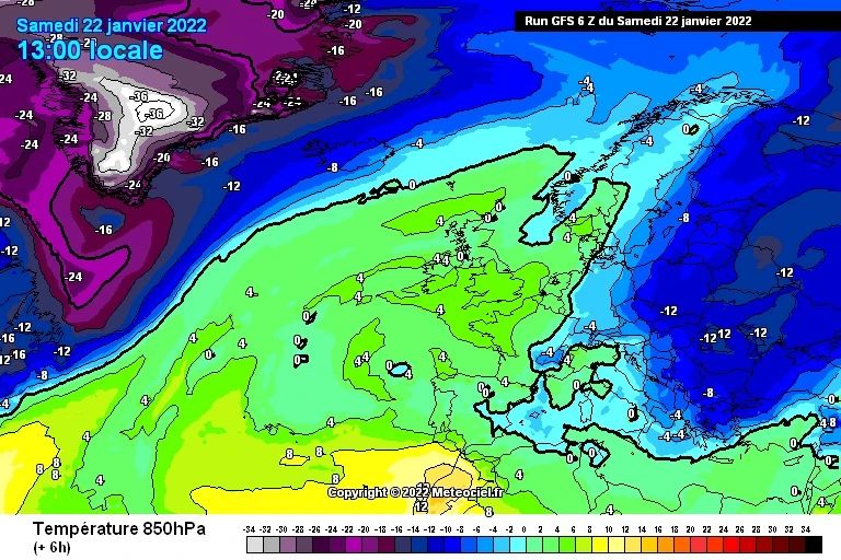
![]() A very deep upper trough/low will maintain its powerful strength over eastern and southeastern Europe, being centered over Ukraine today. The powerful cold advection continues also over the weekend, with actually a pretty extreme temperature anomaly.Keep in mind we are at mid-winter month, January, so 12°C below average at 850 hPa is extreme!The large cold pool will expand across whole eastern and northeastern Europe and the Balkans, as well as across a large part of central Europe.It also partly expands into the Mediterranean, so temperatures will be much lower there as well.
A very deep upper trough/low will maintain its powerful strength over eastern and southeastern Europe, being centered over Ukraine today. The powerful cold advection continues also over the weekend, with actually a pretty extreme temperature anomaly.Keep in mind we are at mid-winter month, January, so 12°C below average at 850 hPa is extreme!The large cold pool will expand across whole eastern and northeastern Europe and the Balkans, as well as across a large part of central Europe.It also partly expands into the Mediterranean, so temperatures will be much lower there as well.
![]() Such a deep core would also promote winter storms and snowfall with accumulation at the end.Eastern and southeastern Europe, including the Balkans, Central Europe, and the Black Sea region could receive some good amount of snow locally.When the storm arrives in Greece and Turkey, heavy snow with dangerous blizzard conditions is expected.The Turkish winter storm will bring an impressive amount of snow especially across eastern Turkey and indeed over the Greater Caucasus
Such a deep core would also promote winter storms and snowfall with accumulation at the end.Eastern and southeastern Europe, including the Balkans, Central Europe, and the Black Sea region could receive some good amount of snow locally.When the storm arrives in Greece and Turkey, heavy snow with dangerous blizzard conditions is expected.The Turkish winter storm will bring an impressive amount of snow especially across eastern Turkey and indeed over the Greater Caucasus
.![]() Graphics provided by Meteociel#nextclima#winterstorm#snowstorm#snow#snowfall#cold#arcticblast#coldoutbreak#ukraine#poland#greece#turkey#georgia#balkans#balkanpeninsula#blacksea#severeweather#extremeweather
Graphics provided by Meteociel#nextclima#winterstorm#snowstorm#snow#snowfall#cold#arcticblast#coldoutbreak#ukraine#poland#greece#turkey#georgia#balkans#balkanpeninsula#blacksea#severeweather#extremeweather


