Larry is forecast to transform into a winter storm that will deliver feet of snow in Greenland.
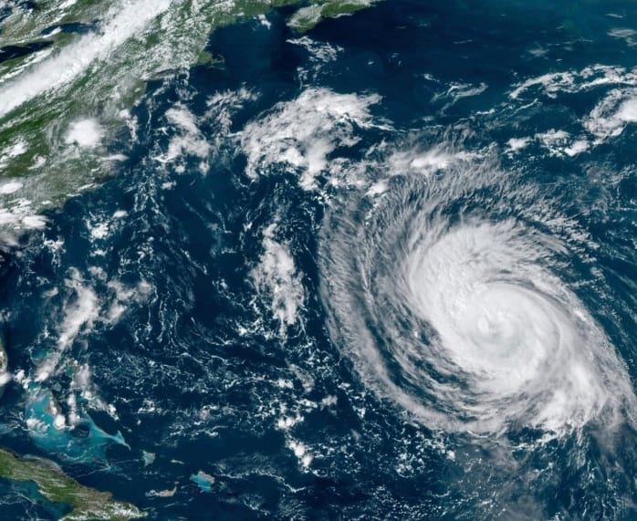
![]() Hurricane Larry made landfall at 11:45 p.m. AST Friday Night in Newfoundland near South East Bight with maximum sustained winds of 80 mph (130 km/h) and an estimated minimum pressure of 960 mb (28.35 inches). Hurricane Larry is forecast to slide up the east coast of Greenland this weekend.When it gets there, it will have sustained winds around 60 to 70 mph, with gusts as high as 85 mph. Larry’s hurricane-force wind likely will produce blizzard conditions across Greenland, although Larry might lose the tropical aspects of a hurricane by then.
Hurricane Larry made landfall at 11:45 p.m. AST Friday Night in Newfoundland near South East Bight with maximum sustained winds of 80 mph (130 km/h) and an estimated minimum pressure of 960 mb (28.35 inches). Hurricane Larry is forecast to slide up the east coast of Greenland this weekend.When it gets there, it will have sustained winds around 60 to 70 mph, with gusts as high as 85 mph. Larry’s hurricane-force wind likely will produce blizzard conditions across Greenland, although Larry might lose the tropical aspects of a hurricane by then.
![]() Larry should become an extratropical cyclone today and is now forecast to be absorbed by a larger extratropical low near Greenland by the end of the weekend. As Larry interacts with this other system, it will be able to pull in a tremendous amount of moisture leading to significant snowfall in Greenland.Widespread totals of 12 to 18 inches are expected in the eastern half of the island nation. Higher elevations along the east coast could get 2 to 4 feet or higher.
Larry should become an extratropical cyclone today and is now forecast to be absorbed by a larger extratropical low near Greenland by the end of the weekend. As Larry interacts with this other system, it will be able to pull in a tremendous amount of moisture leading to significant snowfall in Greenland.Widespread totals of 12 to 18 inches are expected in the eastern half of the island nation. Higher elevations along the east coast could get 2 to 4 feet or higher.
![]() While it is rare for tropical systems to help trigger snow, it’s not unheard of. In fact, just last year Hurricane Zeta brought snow to the Northeast US, including several inches to Massachusetts. What makes Larry a bit more unusual is the timing. Zeta hit in late October.So did Superstorm Sandy, which also helped produce snowfall in October 2012.
While it is rare for tropical systems to help trigger snow, it’s not unheard of. In fact, just last year Hurricane Zeta brought snow to the Northeast US, including several inches to Massachusetts. What makes Larry a bit more unusual is the timing. Zeta hit in late October.So did Superstorm Sandy, which also helped produce snowfall in October 2012.
![]() Graphics provided by NOAA
Graphics provided by NOAA
#nextclima#larry#hurricanelarry#hurricane#newfoundland#southeastbight#greenland#snowstorm#blizzard#snow#snowfall#winterstorm#extratropicalcyclone#extremeweather#severeweather