A long duration winter storm will begin today across the Southern Plains and then stretch as far as New England by Friday.
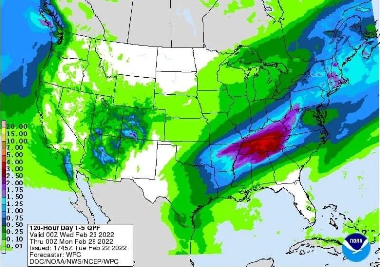
![]() A mixture of snow, sleet, and freezing rain is expected, some of which will be heavy. Significant impacts to travel are likely in many areas.Significant ice accumulations greater than 0.25″ are likely from the Red River Valley of Texas through the Ozarks and southeast Missouri.Locally, damaging ice of 0.5″ or more is possible which could lead to scattered power outages, tree damage and dangerous travel.
A mixture of snow, sleet, and freezing rain is expected, some of which will be heavy. Significant impacts to travel are likely in many areas.Significant ice accumulations greater than 0.25″ are likely from the Red River Valley of Texas through the Ozarks and southeast Missouri.Locally, damaging ice of 0.5″ or more is possible which could lead to scattered power outages, tree damage and dangerous travel.
![]() Another area of freezing rain is likely from the eastern Ohio Valley through the mid-Atlantic states.Significant ice accumulations are possible across south-central Pennsylvania and western Maryland, with hazardous travel possible.Heavy snow is expected across Upstate New York and New England on Friday when snowfall rates will likely eclipse 1″/hr at times.Dangerous travel is likely.
Another area of freezing rain is likely from the eastern Ohio Valley through the mid-Atlantic states.Significant ice accumulations are possible across south-central Pennsylvania and western Maryland, with hazardous travel possible.Heavy snow is expected across Upstate New York and New England on Friday when snowfall rates will likely eclipse 1″/hr at times.Dangerous travel is likely.
![]() Credits: NOAA and Weathermodels#nextclima#winterstorm#southernplains#newengland#newyorkstate#pennsylvania#maryland#ohiovalley#missouri#texas#ozarks#redrivervalley#extremeweather#severeweather
Credits: NOAA and Weathermodels#nextclima#winterstorm#southernplains#newengland#newyorkstate#pennsylvania#maryland#ohiovalley#missouri#texas#ozarks#redrivervalley#extremeweather#severeweather