A deep Atlantic trough will break out from tomorrow, ready to cause rather important effects on a large part of the European continent for which particular attention must be paid.
🌀 Between Wednesday 2 and Friday 4 August the interference of a cyclonic vortex will become increasingly evident over central and southern Europe and is destined to create a real havoc on the weather front.
The first signs will be noticed in the next few hours over Scandinavia and the UK.
Strong winds are modelled to develop on the southern flank of the low, with high-res model GFS showing 40-50 mph gusts inland over southern coastal counties, 50-60 mph along coasts.
As well as the strong winds, outbreaks of heavy rain spreading quickly northeast across much of England and Wales will precede the low arriving from the west, followed by strengthening winds and blustery heavy showers and thunderstorms.
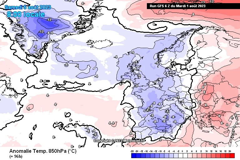
⛈️ Instead, for central and southern Europe it will be the second part of Thursday and above all Friday and Saturday to show a sort of summer crisis due to a severe storm phase that will move very quickly from Benelux, France and Germany to Austria, Switzerland and Italy.
Pay particular attention to the days of Friday 4 and Saturday 5 August, when lots of thunderstorms and heavy rainfall will involve many countries also causing a decisive drop in temperatures with the heat thus forced again to beat a retreat.
They could have strong intensity, accompanied by sudden gusts of wind and dangerous hailstorms.
The weather is expected to improve from Sunday onwards, but we will give you more details about this in the next updates.
📸 Graphics provided by Meteociel