Winter is coming – an intense Arctic blast will spread across much of Europe in the last days of November.
![]() Due to a wide high pressure system, many cities of central and southern Europe are now covered by a lid, also called as inversion, which brings unfavorable scattering conditions and leading to a higher concentrations of pollutants. Generally, the temperature inversion means an increase of temperature with altitude instead of the temperature getting colder.With sufficient humidity, inversions are accompanied by fog or low clouds.This can result in dangerously high pollutant concentrations, creating a smog situation.
Due to a wide high pressure system, many cities of central and southern Europe are now covered by a lid, also called as inversion, which brings unfavorable scattering conditions and leading to a higher concentrations of pollutants. Generally, the temperature inversion means an increase of temperature with altitude instead of the temperature getting colder.With sufficient humidity, inversions are accompanied by fog or low clouds.This can result in dangerously high pollutant concentrations, creating a smog situation.
![]() But a drastic change of the weather pattern is forecast for mid-next week, when the first Arctic outbreak of the winter season is expected and will reach the maximum intensity during the last days of the month.The 850 mbar temperature anomaly chart reveals how large the cold pool is forecast, covering Scandinavia, western and central Europe and afterwards also southern Europe, including Italy and the Balkan Peninsula.Maximum temperatures won’t exceed 5°C in Germany, Benelux, Czech Republic, Austria and Switzerland.
But a drastic change of the weather pattern is forecast for mid-next week, when the first Arctic outbreak of the winter season is expected and will reach the maximum intensity during the last days of the month.The 850 mbar temperature anomaly chart reveals how large the cold pool is forecast, covering Scandinavia, western and central Europe and afterwards also southern Europe, including Italy and the Balkan Peninsula.Maximum temperatures won’t exceed 5°C in Germany, Benelux, Czech Republic, Austria and Switzerland.
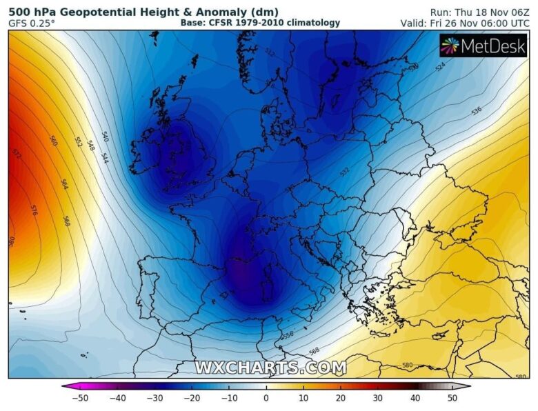
![]() It will be the first cold blast of the season for many countries, with widespread night frosts and first snowfalls at low altitudes.First snowfalls are expected in the plain of Germany, Poland, Czech Republic and in Switzerland and Austria.Snow even at low elevations in the southern Alps, starting from 700/800 meters of altitude. This period could be long-lasting and also early December will be more dynamic with frequent cold fronts spreading across much of Europe.
It will be the first cold blast of the season for many countries, with widespread night frosts and first snowfalls at low altitudes.First snowfalls are expected in the plain of Germany, Poland, Czech Republic and in Switzerland and Austria.Snow even at low elevations in the southern Alps, starting from 700/800 meters of altitude. This period could be long-lasting and also early December will be more dynamic with frequent cold fronts spreading across much of Europe.
![]() Graphics provided by Wxcharts.com#nextclima#winter#fog#inversion#lid#smog#cold#coldoutbreak#coldspell#coldsnap#firstsnowfall#snowfall#scandinavia#germany#france#czechrepublic#austria#switzerland#italy#balkans#alps#extremeweatherVisualizza traduzione+24655Persone raggiunte498InterazioniMetti in evidenza il post
Graphics provided by Wxcharts.com#nextclima#winter#fog#inversion#lid#smog#cold#coldoutbreak#coldspell#coldsnap#firstsnowfall#snowfall#scandinavia#germany#france#czechrepublic#austria#switzerland#italy#balkans#alps#extremeweatherVisualizza traduzione+24655Persone raggiunte498InterazioniMetti in evidenza il post
102Tu e altri 101Condivisioni: 16Mi piaceCommentaCondividi


