A big Nord(west)stau is bringing a lot of snow and strong winds in the Northern Alps and will continue in the next 48 hours.
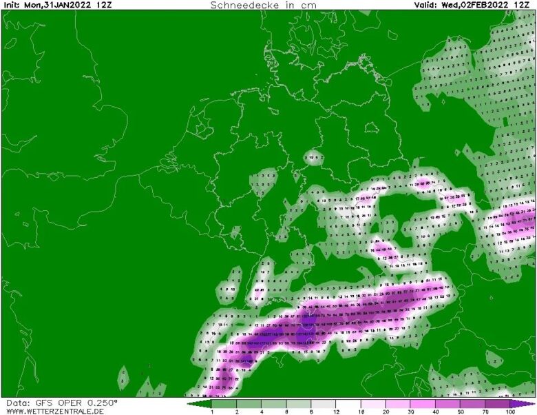
![]() Due to the persistent north-westerly flow it will keep on snowing, especially in the Nordstau areas.In the course of Tuesday night, a new low pressure area will approach bringing in moist air, which will intensify the snowfall once more.Again, 30 to 50 centimetres of snow could fall (locally even more!) from Central Switzerland to Austria.Also in the French Northern Alps this snowfall could bring some snow from Tuesday night on, but whether it’s really going to be the 20 to 40 centimetres that are now on the weather charts is still a bit uncertain.
Due to the persistent north-westerly flow it will keep on snowing, especially in the Nordstau areas.In the course of Tuesday night, a new low pressure area will approach bringing in moist air, which will intensify the snowfall once more.Again, 30 to 50 centimetres of snow could fall (locally even more!) from Central Switzerland to Austria.Also in the French Northern Alps this snowfall could bring some snow from Tuesday night on, but whether it’s really going to be the 20 to 40 centimetres that are now on the weather charts is still a bit uncertain.
![]() Because of the very strong northwestern flow, the wind will play a big role.The large amounts of snow in combination with the stormy wind will create very critical conditions and a very high avalanche risk.From tonight the winds will increase significantly from the northwest as the snowfall continues.While the flow around the Alps on the west and east side will remain strong on Tuesday, the wind will decrease a little bit in the central part of the Northern Alps, but with the approach of the new front the entire Northern Alps will have to deal with stormy winds again on Tuesday evening, which will dominate the weather on Wednesday as well.
Because of the very strong northwestern flow, the wind will play a big role.The large amounts of snow in combination with the stormy wind will create very critical conditions and a very high avalanche risk.From tonight the winds will increase significantly from the northwest as the snowfall continues.While the flow around the Alps on the west and east side will remain strong on Tuesday, the wind will decrease a little bit in the central part of the Northern Alps, but with the approach of the new front the entire Northern Alps will have to deal with stormy winds again on Tuesday evening, which will dominate the weather on Wednesday as well.
![]() Graphics provided by Wetterzentrale #nextclima#windstorm#alps#northernalps#stau#nordstau#snow#freshsnow#smowfall#snowstorm#avalanche#avalancherisk#austria#switzerland#france#severeweather#extremeweather
Graphics provided by Wetterzentrale #nextclima#windstorm#alps#northernalps#stau#nordstau#snow#freshsnow#smowfall#snowstorm#avalanche#avalancherisk#austria#switzerland#france#severeweather#extremeweather


