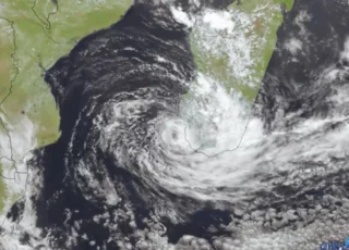
Tropical Cyclone Batsirai is heading southwest and will reach Madagascar on Friday night with gust winds of 130-140 km/h in the western regions.
![]() Rainfall of 250 to 500 mm is forecast for the southeast region of the island with the heaviest rainfall to occur on Saturday and Sunday.These severe phenomena will be accompanied by stormy winds and strong thunderstorms.Batsirai is currently the equivalent of a strong category 3 and may intensify before landfall on Saturday to Category 4 strength with sustained winds near 200 km/h.
Rainfall of 250 to 500 mm is forecast for the southeast region of the island with the heaviest rainfall to occur on Saturday and Sunday.These severe phenomena will be accompanied by stormy winds and strong thunderstorms.Batsirai is currently the equivalent of a strong category 3 and may intensify before landfall on Saturday to Category 4 strength with sustained winds near 200 km/h.
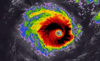
![]() It is forecasted that the system will decrease its intensity once it moves over land and then reintensifies in the Mozambique Channel.Batsirai is expected to make landfall over central Madagascar on Saturday.The system will then continue to track west-southwest across the island and then enter the Mozambique channel and begin to track towards the south.
It is forecasted that the system will decrease its intensity once it moves over land and then reintensifies in the Mozambique Channel.Batsirai is expected to make landfall over central Madagascar on Saturday.The system will then continue to track west-southwest across the island and then enter the Mozambique channel and begin to track towards the south.
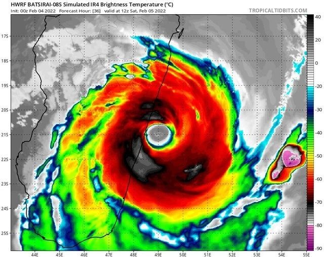
![]() Tropical storms are becoming more nowadays: the island has on average about 1 landfalling tropical cyclone each year, but it’s really rare when storms reaching Category 4 or greater.According to the National Oceanic and Atmospheric Administration’s historical hurricane tracks, there have only been 12 landfalling storms of Category 4 equivalent or greater in Madagascar since records began in 1911, with 8 of them having struck since the year 2000.
Tropical storms are becoming more nowadays: the island has on average about 1 landfalling tropical cyclone each year, but it’s really rare when storms reaching Category 4 or greater.According to the National Oceanic and Atmospheric Administration’s historical hurricane tracks, there have only been 12 landfalling storms of Category 4 equivalent or greater in Madagascar since records began in 1911, with 8 of them having struck since the year 2000.
![]() Graphics provided by Tropicaltidbits and Meteofrance
Graphics provided by Tropicaltidbits and Meteofrance
#nextclima#tropicalcyclone#tropicalstorm#tropicalcyclonebatsirai#batsirai#cyclone#madagascar#mozambique#severeweather#extremeweather