An outbreak of severe to extremely severe storms is forecast in the next few hours across Switzerland, Luxembourg, Germany, Czechia and SW Poland.
🌀 A short-wave trough will move from Spain towards France and Germany by the evening.
As a consequence, a surface low will deepen along the waved cold front.
The low will translate from France to NE Germany in the next few hours.
Today at 12 UTC, a cold front was located in the border area of Germany and France and a warm front stretched from SE Benelux through central Germany into Poland.
The boundary is turning into a cold front and curving through the Baltic countries into Finland.
⛈️ A plume of steep mid-tropospheric lapse rates, originating from N Africa, will have overspread the areas with abundant low-level moisture across large parts of Italy, central and southeastern Europe.
This overlap will yield an unusually large area with CAPE values exceeding 3000 J/kg, even though the majority of the area will not see any initiation due to the strong capping and lack of forcing.
Intense and well-organised storms are expected in the strongly sheared and unstable atmosphere ahead of the short-wave trough and along its attendant frontal system.
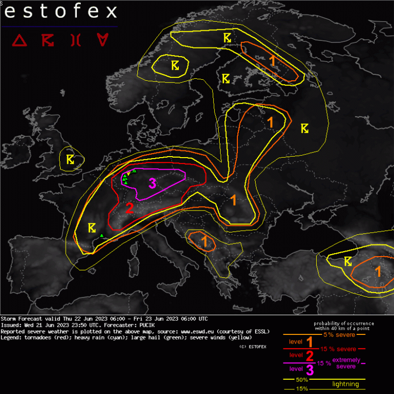
⚠️ A level 3 was issued by Estofex across parts of Germany and Czechia mainly for damaging wind gusts, large to very large hail and (regionally) for tornadoes and heavy rainfall.
A level 2 was issued across Switzerland, W Austria and N Italy mainly for very large hail and severe wind gusts.
A level 2 was issued across central Czechia and SW Poland mainly for damaging wind gusts and large to very large hail.
Credits by Estofex


