Stable and warm weather is expected under the large High in central Europe and the Balkans, pushing the daytime temperature even into the low 20s in some areas in the next few days.
![]() Over the North Atlantic a large cyclone has developed this weekend and will be the trigger for a significant change over Europe.It will cause a strong warm advection from the south towards the north-northeast already today, gradually strengthening and expanding into western and southwestern Europe. The first result of the approaching North Atlantic cyclone will be the re-strengthening of the Azores’ high-pressure system, gradually expanding into southwestern and western Europe from Sunday into Monday.
Over the North Atlantic a large cyclone has developed this weekend and will be the trigger for a significant change over Europe.It will cause a strong warm advection from the south towards the north-northeast already today, gradually strengthening and expanding into western and southwestern Europe. The first result of the approaching North Atlantic cyclone will be the re-strengthening of the Azores’ high-pressure system, gradually expanding into southwestern and western Europe from Sunday into Monday.
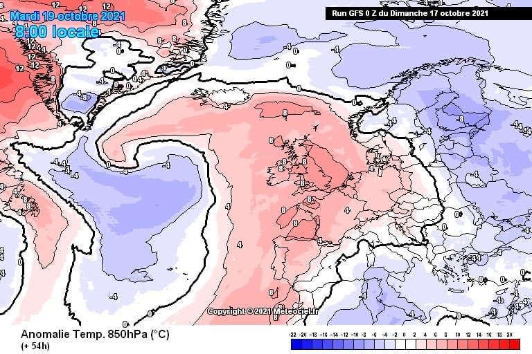
![]() On Tuesday the North Atlantic depression will move towards western Europe, helping the warm advection to maximize across the central parts of the European continent.The strong warm advection to the south of the low will overspread eastern Europe and bring particularly warm Wednesday for the Baltic region. A nearly 10°C warmer air mass will spread the areas from southern Scandinavia across Germany to the northern Mediterranean.
On Tuesday the North Atlantic depression will move towards western Europe, helping the warm advection to maximize across the central parts of the European continent.The strong warm advection to the south of the low will overspread eastern Europe and bring particularly warm Wednesday for the Baltic region. A nearly 10°C warmer air mass will spread the areas from southern Scandinavia across Germany to the northern Mediterranean.
![]() Tuesday will be extremely warm October day in France, with probably 24-26°C across a large part of the country with temperatures closing in the upper 20s in the far southwesterly parts.Even a hot day is not excluded there due to the downslope Foehn flow from the Pyrenees into the valleys to their north.
Tuesday will be extremely warm October day in France, with probably 24-26°C across a large part of the country with temperatures closing in the upper 20s in the far southwesterly parts.Even a hot day is not excluded there due to the downslope Foehn flow from the Pyrenees into the valleys to their north.
![]() Graphics provided by Meteociel
Graphics provided by Meteociel
#nextclima#heatwave#warmweather#october#fall#fall2021#autumn#autumn2021#foehn#centraleurope#westerneurope#france#pyrenees#balticregion#germany#balkans#balkanpeninsula#extremeweather


