A potentially record-breaking warmth is increasingly likely to develop across a large part of Europe next week and quite likely also extend into the last days of October.
🌡 A very powerful upper-level ridge will develop into the European continent by the middle of next week.
In the meantime, some rainfall is expected in Portugal, Spain, France and the UK, due to a large trough in the Atlantic that will affect western Europe.
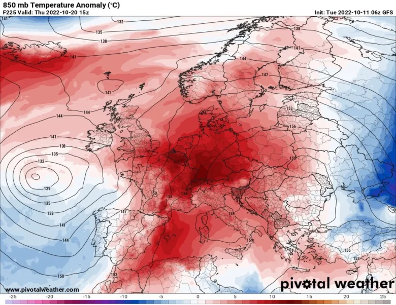
A much warmer air mass will spread across southern, central and also eastern Europe.
It seems that the warmest air mass will be across the central parts of the continent, especially over France, Germany, Austria, Switzerland, Italy and the Balkans with even more than 12°C above normal for mid-October.
🔥 It will be very mild for this time of the year, with highest temperatures locally above 25 degrees in some locations of Spain, France and Italy.
Very warm also in Germany, Austria and Switzerland with a 2m temperature anomaly of around 8°C.
Last Sunday temperatures jumped to 29.9°C at Zumaia and 29.7°C in the San Sebastian Airport in Spain, while in France the high was 29.8°C at Saint-Gladie.
Next week the new warm spell will likely break many October records.
📸 Graphics provided by Pivotal Weather


