Storm Celia over Spain is pulling a dust cloud up from the Sahara which has reached the south of the UK in the last few hours.
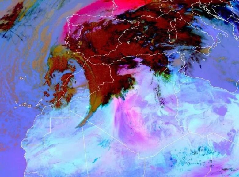
![]() A pretty impressive amount of Saharan dust is being advected across southwestern and central Europe, ahead of the upper low, named Storm Celia, centered over Morocco.The dust cloud, which is 2 km above ground level, may fall during showers in southern UK by the evening.It comes as parts of southern Spain have been blanketed after a thick plume that has turned skies orange, with satellite images clearly showing the dust over France.The impact is unlikely to be significant over UK, with the dust potentially most visible at sunset.
A pretty impressive amount of Saharan dust is being advected across southwestern and central Europe, ahead of the upper low, named Storm Celia, centered over Morocco.The dust cloud, which is 2 km above ground level, may fall during showers in southern UK by the evening.It comes as parts of southern Spain have been blanketed after a thick plume that has turned skies orange, with satellite images clearly showing the dust over France.The impact is unlikely to be significant over UK, with the dust potentially most visible at sunset.
![]() An influential low pressure over NW Africa and southern Iberia is bringing very unsettled conditions to the Canary Islands, Spain, Portugal.Storm Celia is gradually moving east, bringing most of the significant rain confined to eastern Spain and Balearics for the next couple of days.In the meantime, a feed of red Saharan dust is moving across the Mediterranean into western Europe on this warmer, moist flow.It has coated Spain on the ground and given red skies, reached Germany and is affecting SE Britain today.The Pyrenean snowcaps are tinged orangey pink and the Saharan dust is now moving across the English Channel over southern England.
An influential low pressure over NW Africa and southern Iberia is bringing very unsettled conditions to the Canary Islands, Spain, Portugal.Storm Celia is gradually moving east, bringing most of the significant rain confined to eastern Spain and Balearics for the next couple of days.In the meantime, a feed of red Saharan dust is moving across the Mediterranean into western Europe on this warmer, moist flow.It has coated Spain on the ground and given red skies, reached Germany and is affecting SE Britain today.The Pyrenean snowcaps are tinged orangey pink and the Saharan dust is now moving across the English Channel over southern England.
![]() Graphics provided by EUMETSAT, Copernicus and NASA#nextclima#stormcelia#saharandust#calima#iberia#gibraltar#englishchannel#pyrenean#spain#portugal#canaryislands#france#italy#alps#switzerland#austria#germany#uk#benelux
Graphics provided by EUMETSAT, Copernicus and NASA#nextclima#stormcelia#saharandust#calima#iberia#gibraltar#englishchannel#pyrenean#spain#portugal#canaryislands#france#italy#alps#switzerland#austria#germany#uk#benelux


