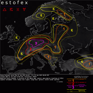
A level 2 for severe weather has been issued by Estofex for the next few hours across parts of Switzerland, south/southeastern Germany, Austria, northern Italy to Croatia mainly for severe/damaging wind gusts and large to very large hail.
![]() A multicell/supercell mixture is forecast over south-eastern France, Switzerland and south/south-central Germany with large hail and severe wind gusts as main threat.
A multicell/supercell mixture is forecast over south-eastern France, Switzerland and south/south-central Germany with large hail and severe wind gusts as main threat.
An isolated very large hail and extreme severe “downburst” gust is possible and initial slow motion could yield locally excessive rainfall amounts.
The level 2 has been issued over eastern Austria as there are no real indications for a mature MCS (mesoscale convective system) to not race that far east before weakening.
Over northern Italy a long-lived severe MCS event is expected with damaging wind gusts and large/very large hail.
![]() A level 1 surrounds the level 2 for similar hazards but with less coverage.
A level 1 surrounds the level 2 for similar hazards but with less coverage.
The level 1s over eastern France/Benelux and northern Germany were issued mainly for heavy rain and a low-end tornado risk (Belgium/the Netherlands).
A level 1 was issued for western Turkey mainly for heavy rain.
The level 1 was expanded north to cover the risk of slow moving thunderstorms with heavy rain and isolated hail as DLS is forecast in the 10-15 m/s range.
Over Belgium/the Netherlands an isolated tornado event is possible along the periphery of the N-ward moving LL depression.
Once again another round of slow moving convection over western Turkey is forecast with a heavy rainfall threat (local flooding issues).
Credits: Estofex
#nextclima#severeweather#extremeweather#storm#mcs#thunderstorm#tornado#supercell#flooding#hail#downburst#switzerland#austria#italy#belgium#netherlands#benelux#france#germany#turkey#slovenia