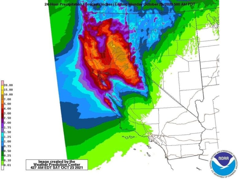
A powerful storm will bring heavy rain and strong winds to California into Monday.
☔ The area of low pressure from this storm became a bomb cyclone over the eastern Pacific Ocean Saturday into early Sunday, a term for a low-pressure system whose central pressure plunges by at least 24 millibars in 24 hours or less.
NOAA’s Weather Prediction Center has issued a “High Risk” for flash flooding in portions of the northern Sierra foothills with the expectation that flash flooding will occur along with debris flows.
The National Weather Service has issued flood watches for much of Northern and Central California, including several burn areas in Northern California and the southern Sierra including the Dixie and North Complex burn scars.
⚠️ Flash flooding and debris flows could become more widespread because of the heavier rain, especially in and around the recent burn areas.
Many areas of Northern California especially north of Interstate 80, will likely pick up at least 3 inches of rain through Monday.
Windward locations in the coastal ranges of Northern California, as well as the Sierra foothills below snow level, should see over 5 inches of rain.
Locally, a foot of rain could fall.
📸 Credits: NOAA
#nextclima #bombcyclone #flooding #flashflooding #debrisflows #heavyrain #severewinds #california #sierra #pacificocean #extremeweather #severeweather