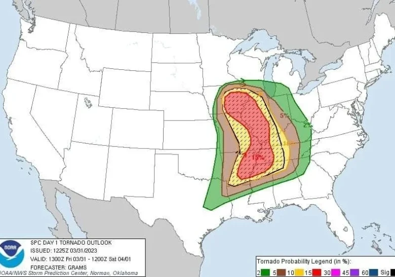
A major early spring storm system is forecast to impact the central and eastern United States with severe thunderstorms, high winds, and heavy snow from March 31 to April 1, 2023.
⚠️ The Storm Prediction Center has issued a Moderate Risk (level 4/5) of severe thunderstorms across parts of southeast Iowa, northwest Illinois, and northeast Missouri, as well as a separate area from northeast Arkansas to far western Kentucky.
Severe weather, including damaging wind gusts, large hail and several tornadoes (some strong), is expected between the Midwest and Lower Mississippi Valley.
☔️ The greatest risk for flooding resides across the Ohio, Tennessee, and Lower Mississippi valleys through tonight.
By Saturday, April 1, a trailing secondary cold front could lead to forming thunderstorms capable of containing damaging wind gusts across the northern Appalachians and Interior Northeast.
🌨 Heavy snow and patches of freezing rain are likely from South Dakota to the Upper Peninsula of Michigan through Saturday morning, with blizzard conditions expected for parts of South Dakota and southwestern Minnesota.
Heavy snowfall rates and gusty winds as high as 80 km/h (50 mph) could lead to snow-covered roads and near-zero visibility at times.
📸 Graphics provided by Weathermodels.com and NOAA