Winter Storm Atticus will bring snow to parts of the West, Plains and Upper Midwest through late this week, from California to Michigan.
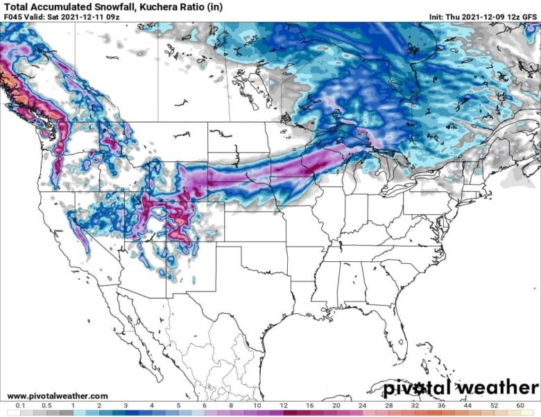
![]() Snow will blanket the Sierra, parts of the Great Basin and Rockies from Nevada into Utah, Wyoming and western Colorado through Thursday.This could make for a snowy Thursday afternoon commute in Salt Lake City and be the city’s first measurable snow of the season.Beginning Thursday night, snow will spread east into the Plains, from Wyoming and northern Colorado into parts of Nebraska, South Dakota and southwest Minnesota.Friday, snow will continue from parts of Colorado and Wyoming to Minnesota and spread into eastern Nebraska, northern Iowa, Wisconsin and northern Michigan.
Snow will blanket the Sierra, parts of the Great Basin and Rockies from Nevada into Utah, Wyoming and western Colorado through Thursday.This could make for a snowy Thursday afternoon commute in Salt Lake City and be the city’s first measurable snow of the season.Beginning Thursday night, snow will spread east into the Plains, from Wyoming and northern Colorado into parts of Nebraska, South Dakota and southwest Minnesota.Friday, snow will continue from parts of Colorado and Wyoming to Minnesota and spread into eastern Nebraska, northern Iowa, Wisconsin and northern Michigan.
![]() The heaviest snow is expected over the high country of Colorado where over a foot of snow is likely. At least 6 inches of new snow is likely over the Sierra and Utah’s Wasatch. A few inches of snow are also likely in Salt Lake City, and perhaps an inch or so is possible in Denver. In the Plains, 6 inches of snow are possible from southeast Wyoming into northern Nebraska, southern South Dakota, northern Iowa, southern Minnesota, central and northern Wisconsin and northern Michigan.
The heaviest snow is expected over the high country of Colorado where over a foot of snow is likely. At least 6 inches of new snow is likely over the Sierra and Utah’s Wasatch. A few inches of snow are also likely in Salt Lake City, and perhaps an inch or so is possible in Denver. In the Plains, 6 inches of snow are possible from southeast Wyoming into northern Nebraska, southern South Dakota, northern Iowa, southern Minnesota, central and northern Wisconsin and northern Michigan.
![]() Graphics provided by Pivotal Weather #nextclima#stormatticus#atticus#winterstormatticus#winterstorm#plains#michigan#wisconsin#minnesota#iowa#dakota#nebraska#wyoming#saltlakecity#sierra#colorado#rockies#extremeweather#severeweatherVisualizza traduzione936Persone raggiunte88InterazioniMetti in evidenza il post
Graphics provided by Pivotal Weather #nextclima#stormatticus#atticus#winterstormatticus#winterstorm#plains#michigan#wisconsin#minnesota#iowa#dakota#nebraska#wyoming#saltlakecity#sierra#colorado#rockies#extremeweather#severeweatherVisualizza traduzione936Persone raggiunte88InterazioniMetti in evidenza il post
2929Condivisioni: 2Mi piaceCommentaCondividi


