Winter Storm Hudson is hammering the western United States with heavy mountain snow, flash flooding and strong winds.
🌨 The strong storm system will continue to strengthen as it pushes across the Rocky Mountains bringing heavy rain and snow to parts of the southwest.
Snow will then begin to impact parts of the northern Great Plains Monday into the day on Tuesday.
The snow will affect a large part of the country stretching from California into Wisconsin. Some locations in the Rocky Mountains and Great Plains could receive over 2 feet of snow by the end of the week.
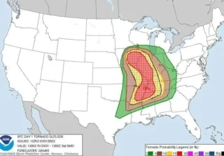
⛈️ The warm side of the storm system will bring the chance for severe thunderstorms in parts of the deep south.
The strong cold front will roar into the south tomorrow afternoon and the combination of vertical wind shear and instability will bring the possibility of large hail, damaging wind gusts and tornadoes.
The Storm Prediction Center (SPC) has placed parts of Arkansas, Louisiana, Oklahoma and Texas in a level 3 out of 5 for severe thunderstorms tomorrow.
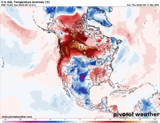
🚩 Record warmth will be possible in the eastern and northeastern United States ahead of the cold front.
The forecast high temperature in Youngstown on Tuesday is 62°F, which would break the record of 61°F set all the way back in 1950.
Record warmth will be possible in Youngstown on Tuesday.
The record warmth will also bring rain chances back into the area Monday night into Tuesday.
Some of this rainfall could be heavy and the Valley can expect 1 to 1.5″ of rainfall through late Wednesday.
📸 Graphics provided by NOAA and Weathermodels